
October 2021
17km (10.5 miles)
- Estimated time to complete according to brochure: 6 – 8 hours
- Our time: 8.5 hours
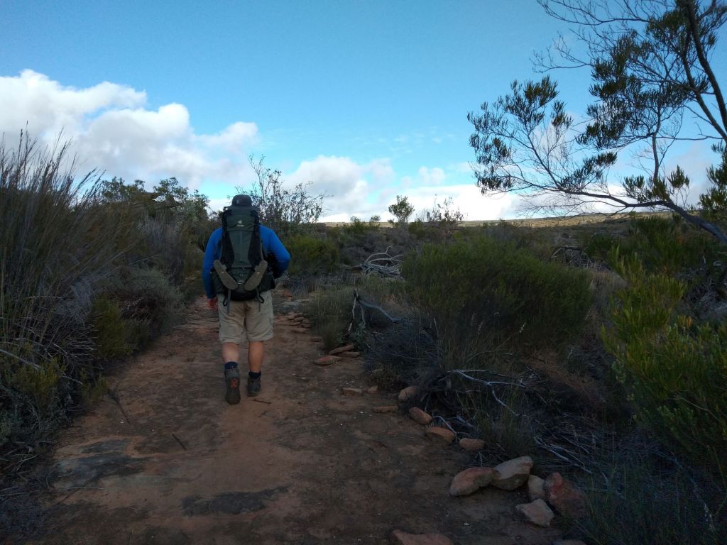
Quite surprisingly, it was not so difficult this morning to get up. Could it be that our bodies are now starting to get use to move over all these big rocks? Well, it is day 4 after all …


We did not really talk about the ‘escape route’ last night … but when we left our hut at around 6:45, we crossed the bridge and then Berto came to a halt at the sign post indicating the escape route. He looked at me and lifted his eyebrows … I smiled and started to walk in the opposite direction. We only have 2 more days on this trail and can just as well finish it!

The first few kilometers were easy walking (that’s more how I would like to start a morning) and we enjoyed the early morning in nature.

When we looked ahead, we realised that we had to climb a small(ish) mountain to get back on to the plateau, but first we walked past beautiful Cape willow trees and lovely smelling fynbos bushes.

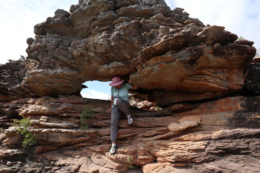
As we got closer to the mountain we had to climb, we started to see more and more amazing rock formation.

And then the scrambling started … up and up and up the mountain. Once again over big rocks and sometimes using the (by now) well-known ladders.


It took as more than an hour to get back to the plateau! Out of breath and with tired arms and legs, we sat down to rest for a while. We have now walked 23km (according to the kilometer marker), but by now, you know what I’m going to say … yes, we actually walked 27km (still adding that 4km of day 1)!

In the brochure we read that we will pass through ten rock arches today. It was not long after the 23km marker that we saw the first of these arches.


Although the brochure mentioned that the “trail will level out and meanders along the edge of the plateau”, in reality we actually spent most of our time climbing over rocks and going through narrow spaces.


After climbing rocks for almost an hour, I said to Berto we need to rest for a while. It’s amazing how you know you need to lift your legs to get onto a rock, but your body just refuse to work together with your mind! Berto recognised that I was in serious need of some energy … and he pulled out the best medicine ever out of his backpack … jelly sweets!!

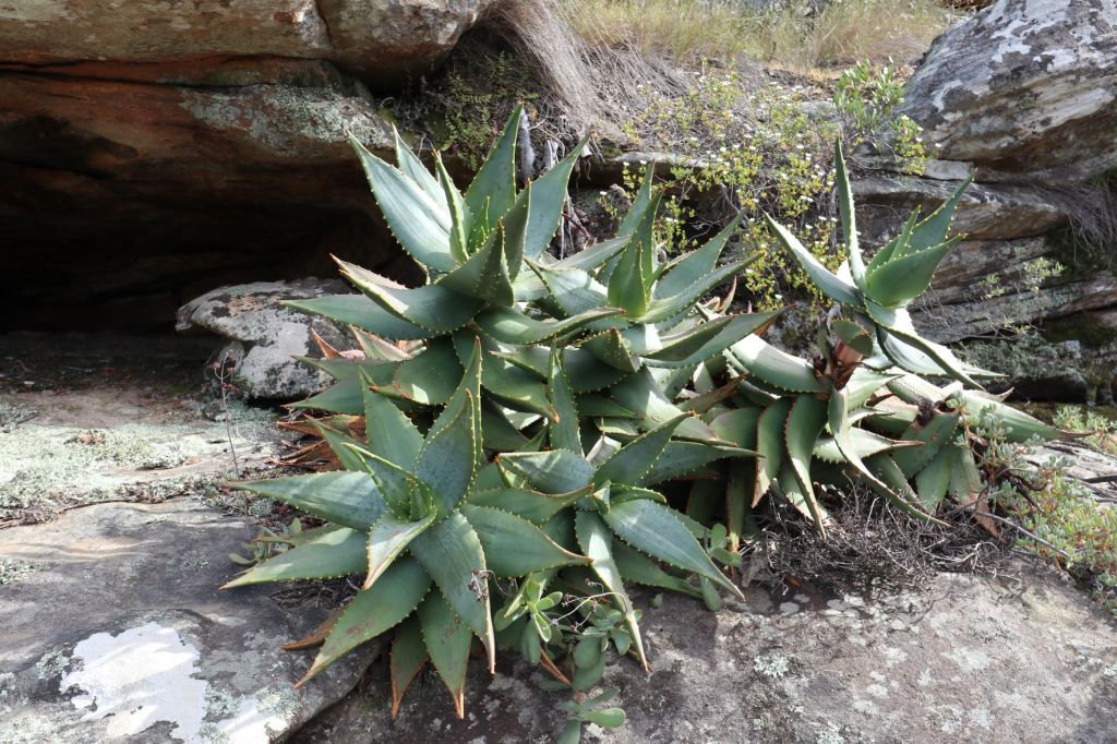
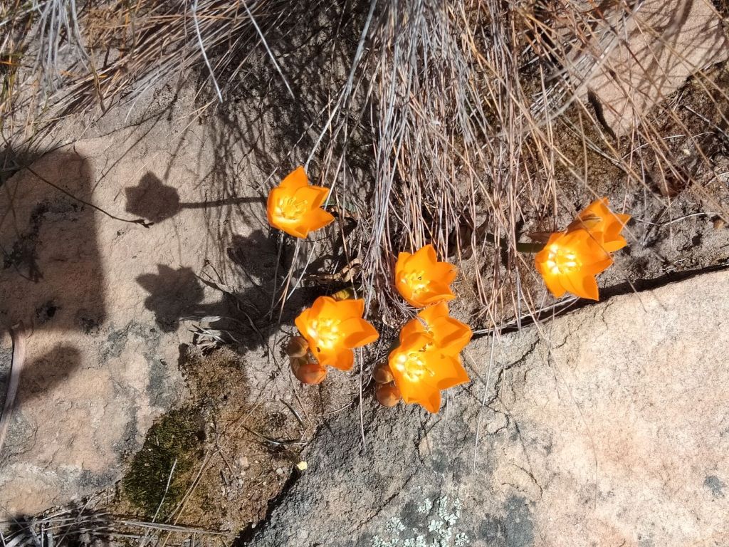
With renewed energy, we got back on the trail. And still nature surprised us with her beautiful flowers. We saw so many proteas on this hiking trail … and I never get tired of seeing them!


I’m not sure how often the trail are checked by the staff of Oorlogskloof Hiking Trail (it is after all not that easy to quickly take a vehicle and do a circular route). Some of the huts’ windows were broken and the ladders, ropes and chains looked quite old.
Sometimes, when I had to pull myself up a rock with either a rope or chain, the thought did cross my mind if it will hold me … remember yesterday’s chimney? On today’s stage, we got to a ladder where we had to climb down a rock – with one broken step. It looks like a ‘fresh’ break and I hope the staff are checking the trail for maintenance.

We were still walking/climbing on the edge of the plateau where we saw some really amazing rock formations.


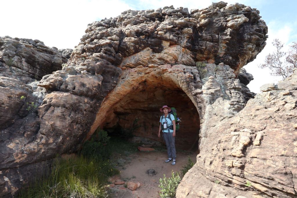

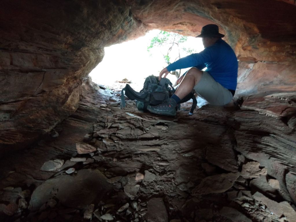
In the brochure, we were warned about crawling through some narrow tunnels on today’s stage (at least I’m not claustrophobic).


Close to the 29km marker, we came to a really narrow tunnel! It was about 20m long … not that long, but when you have to move on your butt and pull your backpack with you (while you must be careful not to bump your head on the rock above), it can be a very long tunnel!


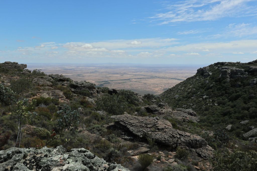
Just after the 29km marker, there is a detour of 2.6km to ‘Arrie se Punt’ (a viewpoint with a magnificent panorama of the Knersvlakte). The name ‘Knersvlakte’ (literally translated it would mean ‘gnashing plain’) is thought to be derived from the crunching of wagonwheels as they moved over the hard quartz stones.
We decided not to take the detour – had enough of rock climbing for the day – but we were still rewarded with amazing views a bit further on the trail as it skirts the edge of the escarpment.

And guess what? It was still not the end of rock climbing … at times it was quite high and Berto had to use a rope to pull my backpack up while I had to drag my body up!

For about 1km we had some easy walking on a path dotted with more proteas and other pretty flowers.


After the sandy path, we descended into ‘Kouekloof’, crossing a seasonal stream (where we filled our water bottles again) and then returned to the edge of the plateau again. Up and down, up and down … this is how this day turned out!
Near 35km we had to go through 2 caves. One was relatively easy, but the other one was pretty high and by this time I was close to giving up … it was a LONG day!


The last ‘surprise’ waiting for me before the end of the day’s trail was a VERY STEEP descend around ‘Pramkoppie’ (named after its resemblance to a breast) … seriously, one can take only SO much on one day! Berto took my hand and literally lead me down the mountain!


All I needed after this day, was a shower and a bed! And then, to my dismay, there was no shower at the hut! Well, there was a shower, but no water came from the taps.

Shower time:
Berto noticed a water tank about 100m from the hut and took a bucket from the hut … and hallelujah, we found water!! So, there we were – naked in front of the hut, throwing water from the bucket onto each other! Fortunately, there were no other people – but the baboons were laughing from the mountain tops!
And then … the BEST memory for me of this hiking trip … we sat on the porch – NAKED – with a glass of red wine and watched the sun go down!

Our hut also had no electricity (although there were solar panels), but fortunately we had our headlamps… if we were not so tired, it could have been very romantic! All that had to be done before we could fall into our beds was to make dinner!

Here are the maps of the day:


Another tiring day … maybe we should have taken that ‘escape route’ this morning … but then, we had some stunning views today!
Tomorrow … our last day …
You can read about Day 5 here

Spectacular rock formations on this part of the trek. I think it could be hard to follow the trail in the rocky area.
LikeLiked by 2 people
Yes John, I must agree … the rock formations on this day was just out of this world! At first I also thought it would be difficult to follow the trail (with rocks everywhere), but one’s eye gets trained in looking for the small rocks stacks (we did miss the trail a couple of times, but fortunately we could find it again). Thanks for still following our Oorlogskloof Hiking Trail … we’re almost at the end!
LikeLiked by 1 person
What a fantastic adventure you’re having. Yes, you guys have been challenged but you must be proud of yourselves. Loving the photos of the rock formations and the flowers. Cheers, Mark
LikeLiked by 2 people
It was indeed an adventure Mark! And you’re right, the rock formations and flowers on this day was really spectacular – I’m glad we did not take the ‘escape route’ earlier 😉. Thank you, we felt quite happy (and proud) to have finished this trail … in one piece!
LikeLike
Wow, Corna nog ‘n uitmergelinde dag! Die rotsformasies is ongelooflik mooi en so baie grotte! Die veld blomme en proteas is ook sommer n bonus ne! Wel hier gaan my laaste 4 hoede😄👨🌾👩🌾👨🌾👩🌾 Sal nog moet gaan soek! Julle twee is ongelooflik braaf om daar te kan stap. My Ronde kort lyf sou nooit dit kon doen nie! Die stort en sit op die stoep klink net so amazing 😄 ek veronderstel dat die sterre ook ongelooflik mooi moes wees!
LikeLiked by 2 people
Ag, dankie vir jou mooi kommentaar Aletta! Ja, dag 4 het ons totaal en al verras met al die uitsonderlike rotse en pragtige blomme! En moenie te veel bekommer oor nog ‘n hoed nie – dag 5 se hoed kan net ‘n klein pet wees 😅! Daardie stoep-sit was heerlik 😄 en jy’s reg … die sterre het soos kersliggies in die hemelruim gelyk!
LikeLike
Daai sterre is die beste as dit so pikdonker is😊
LikeLiked by 1 person
Dis baie waar Aletta!
LikeLike
Those spectacular rock formations and far reaching views must have helped to make up for the arduous hiking you had to endure during the day. It’s dangerous that the route isn’t fully maintained with rungs missing off ladders here and there, but I expect it is checked periodically. It’s hard enough you both taking the trail let alone thinking of those needing to carry tools and maintenance equipment. Wine in the sunset was a just reward for your exertions Corna. A very enjoyable read.
LikeLiked by 2 people
Absolutely Marion, I’m so glad we did not choose the ‘escape route’ … otherwise we would have missed all of these amazing rock formations and stunning views! I have no idea how the staff of the Oorlogskloof Hiking Trail is taking care of the broken stuff (like you’ve said, it must be quite exhausting to carry a tool box around in this area)! We did not even see a road leading to two of these huts 👀.
That wine and that sunset was THE best! Thanks for continue to read about our Oorlogskloof Hiking Trail … just one more day! Have a good weekend 💌.
LikeLiked by 1 person
The rock formations look pretty incredible with all those caves and arches, but oh wow, does it look like tough work to climb over, under, around and through some of them. It sounds lovely to have the hut all to yourself. I couldn’t help but laugh that you enjoyed a glass of wine while sitting naked on the porch. Well done.
LikeLiked by 2 people
The rock formations were just incredible … I’m glad we did not choose the ‘escape route’ (just look at what we would have missed)! I think it must be great to be a group on a hike like this – but then we would not have the opportunity of drinking a glass of wine naked on the porch of the hut (don’t worry, we had a good laugh ourselves 😅). Thanks for your lovely comments.
LikeLiked by 1 person
Those narrow caves would have been too much for me. I have to be able to move my arms around. Surely you must have lost a ton of weight, doing all that? Tough, tough hike but what an accomplishment and you got to see those great rock formations and the wonderful protea. Wonderful reading all this!
LikeLiked by 1 person
Yes, it was wonderful to see those rock formations and the lovely proteas (my favourite flower in nature)! We lost some weight (maybe not a ton 😉), but enough that we could see a difference … but I’m sure there’s other ways to loose weight (like eating less in stead of climbing rocks everyday)! I’m so glad you enjoy our Oorlogskloof Hiking Trail stories … only one more day to go!
LikeLiked by 1 person
Another thrilling instalment, to say you guys are intrepid hikers is no understatement. Those rock formations…
LikeLiked by 2 people
Thanks Leighton! I must admit, I felt like Edmund Hillary after this hike (though I know it’s far from the truth 😄). The further we went on the hike, the more worried we became of the condition of some of the ladders, ropes and chains … but hopefully it gets maintained regularly. Oh yes, those rock formations … just unbelievable, hey!
LikeLiked by 1 person
I get exhausted just reading these posts! But the views are stunning, the rock formations amazing and the flowers, especially the proteas, beautiful 😀
LikeLiked by 2 people
Sarah, I’m exhausted by just typing the story again 😉. But you’re absolutely right, the views on this day was just breathtaking! Oh, I love the protea – such a unique flower. Thanks for still hiking with us in Oorlogskloof … the last day is coming up soon!
LikeLiked by 1 person
Another amazing day. You guys are really creating some memories! Mel
LikeLiked by 2 people
Oh yes Mel, this was quite a day – all those beautiful rock formations! And memories … for sure!
LikeLiked by 1 person
Another amazing hike, this is more than the difficult standard rating, for sure! The good side of your hike is that you’re having a hut waiting for you at the end of each day (although no water). No need to carry your tent, not that you’re not having enough on your backs.. The rock formations and the flowers are so amazing, your effort was well rewarded!!
LikeLiked by 2 people
I’m glad you feel it rates difficult … definitely my feeling as well! Oh yes, so glad we didn’t had to pitch a tent (I swear I would have slept right there under the stars 😅). The rock formations on this day was really spectacular – I’m glad we didn’t bail out on the third day! Take care, Corna.
LikeLiked by 1 person
I really admire you! And such beautiful views and rocks and vynbos was your reward. Wonderful!
LikeLiked by 2 people
Ah, thanks for the lovely comment Morag 💌. I’m so glad we did not choose that escape route … look at what we would have missed! Nature is such a wonderful place (even when you have to work hard to get to the beautiful spots – I’m saying now a few weeks later 😉). Thanks for “walking” with us … only one more day! Wishing you a good night’s sleep and a great week xx
LikeLike
Thank you, same to you, hugs.
LikeLiked by 1 person
Sjoe! Julle is behoorlik beproef! Dankie dat jy die moeite gedoen het om dit met ons te deel.
LikeLiked by 1 person
Jy’s reg Toortsie – ‘n beproewing en ‘n half! Daar was darem ook baie mooi om te sien (maar soms was ek net te moeg om dit regtig raak te sien 🙁).
LikeLiked by 1 person
En nou die pragtige en wonderlike herinneringe.
LikeLiked by 1 person
Net so 😀
LikeLiked by 1 person
Corna, I admire you and your husband for doing this adventurous hike. I think the tour is dangerous at times and anyone who is not very good at climbing has to be very careful. It is exciting for me to look at your wonderful photos. What a fantastic adventure you’re having!
Corna, I wish you all the best!
Rosie from Germany
LikeLiked by 2 people
Thank you so much for your lovely comments Rosie! Yes, you’re absolutely right … doing this hike, one needs to be very careful as there are some really dangerous spots! But the views were really rewarding – and it was quite an adventure as you’ve mentioned 😁.
Thank you for reading about our latests hiking trip, take care. Greetings Corna
LikeLiked by 1 person
I think I have a lot of respect for this difficult tour. I would definitely have to do some climbing training beforehand. Thank you for your exciting report, Corna!
LikeLiked by 1 person
Maybe I should also have done some climbing training beforehand Rosie 😉 … it might have been easier then. I’m glad you enjoyed our Oorlogskloof Hiking story!
LikeLiked by 1 person
This is definitely favourite day of your hike. All of those fantastic rock features, Arches and caves. You’re really enticing me to travel to SA for this trek! Maggie
LikeLiked by 2 people
That’s true Maggie … if I have to choose my favourite day, it would definitely be day 4! The rock formations and arches were just breathtaking beautiful! I’m sure you would love this kind of hiking (and there’s so much more to do in SA than just hiking in the mountains) 😉.
LikeLike
Those rock formations are incredible, though I’d have got claustrophobic wiggling through some of those tunnels. The sunset and sunrise look amazing, though I bet not as amazing as a shower would have looked! Can’t wait for the final installment 🙂
LikeLiked by 2 people
The rock formations on this day were really spectacular Hannah! The tunnels were quite narrow … but you could at least see daylight on both sides 😉. Oh, how much I would have appreciated a shower at the end of this day – at least the “bucket shower” provided a lot of fun !!
LikeLiked by 1 person
How cool, Corna! You guys will be able to instruct mountaineering when you’re done with this journey! You & Berto are so adventurous, I love it! 🌞
LikeLiked by 1 person
Haha Lisa, you’re so funny 😅 … no, I think we’ll leave the real experts to do that mountaineering thing! This was a really adventurous hike – I think we need to slow done a bit!
LikeLiked by 1 person
The arches and tunnels must have been a challenge, but such interesting formations! We have an Arches National Park in Utah and my son and I have hiked the trails there, but have never wiggled through the openings! I’m exhausted just reading some of these hikes!
LikeLiked by 1 person
It was indeed a challenge (but you’re absolutely right, we were really mesmerised by these formations)! Oh yes, I saw some amazing photos of your Arches National Park – what a wonderful privilege to be able to walk in this beautiful place! Haha, I got tired from just writing the story again 😄 … it was definitely one of our more adventurous hikes!
LikeLiked by 1 person
Beautiful! I’m so glad that you did not take the escape route! You are both amazing and I loved the beautiful views, proteas and pincushions, thank you for a great share 🌸💕
LikeLiked by 1 person
I’m also glad we didn’t take the escape route … look at what we would have missed! This was surely the most beautiful day of the hike – those rock formations, oh and the proteas and pincushions – just so beautiful! Thank you for reading about our adventurous hike!
LikeLiked by 1 person